Introduction
During the lockdowns of 2020, members worked from home exploring the written evidence of Kildale’s past. The original manuscript material may be found in The National Archives at Kew or the Borthwick Institute in York and elsewhere. Much of it has been transcribed, edited and published in book form by the archives themselves or by organisations such as the Yorkshire Archaeological Society that began publishing a series of important Yorkshire records in 1885. Many such published records are now available online so they can be explored and collated, together with looking at books on the history of Cleveland or of North Yorkshire that have been written since the 18th century onwards.
Canons of St John the Evangelist
Within all of this material there are intriguing snippets of information about a lost chapel that once existed somewhere in the parish of Kildale. In the 13th century (the exact year is uncertain but it was between 1235 and 1257) Sir William de Percy, the Lord of the Manor of Kildale gave the Chapel of St Hilda, located in one of the three parks in Kildale, to the canons of St John the Evangelist at Healaugh Park Priory; this was an Augustinian priory established in 1218, two miles north of Tadcaster. He also gave some pieces of land in Kildale to support the chapel, the rent of 2 marks a year from his water mill, the right to grind corn at the mill and a supply of corn and malt for those who stay at the chapel. There was a further grant of land located at Crathorne, near Yarm. These grants were intended to provide future benefits for the health of his soul. The original sources giving details of the grants seem to suggest that a pre-existing chapel was given and not just land, so its origins could have been even earlier1A translation of the Chartulary of the Augustinian Priory of St John the Evangelist of the Park of Heelaugh can be viewed here.
In return for the grants the canons had to provide two priests to celebrate divine service in the chapel. Sir William’s son Sir Arnold de Percy reduced the requirement from two priests to one, but in return for the Crathorne land a chaplain was required to celebrate in the chapel of St. Nicholas, Yarm, for the souls of Sir William de Percy and others. At some point in the early 14th century the Prior of Healaugh returned the chapel and all of the Kildale land to Sir Arnold.
The Crutched Friars
Sir Arnold gave the Brothers of the Cross, also known as the Crutched Friars, permission to use the chapel and also gave them some land. This may have been in 1307 when they were forced to leave York by the Archbishop but must have been some time before 1310 because in that year there was “Pardon to the prior and brethren of Kyldale for acquiring in mortmain, without licence, from Arnald de Percy a messuage and 10 acres of land in Kyldale, co. York; with restitution of the same”. Taxation when land was inherited was a major source of revenue for the King but that was blocked if property was given to a body such as the Church that never died. Mortmain meant literally “dead hand”. From 1279 a licence had to be obtained from the King before such gifts of land, but the system may not have worked very well as pardons can often be found in the archives.
The Archdeacon of Cleveland’s interdiction
By 1312 it came to the attention of the Archbishop Greenfield of York that the Brothers were in his area without his permission or approval of the Pope, in “oratories and places not adequately dedicated”. There was also concern that the incumbent of Kildale parish church had losses because some of his parishioners were attending the chapel instead of the church. There was a year of delay but on 3rd February 1314/15 the Archdeacon of Cleveland issued an interdiction forbidding the brothers from celebrating divine offices, leading to the departure from Kildale of the Crutched Friars, never to return. However a 1985 book, The Changing Face of Kildale, mentions a visit from a member of the Order, looking for the site of the chapel about 20 years before the book was written 2Ridley, I.R. “The Changing Face of Kildale”. Stokesley & District Local History Study Group. 1985.. The monastery of Claire Lieu by Huy on the Meuse in Belgium was the mother house of the order. It had a number of similar failures to make lasting establishments in England, including one at Osmotherley, succeeding only in London, Barham, Donington and Colchester.
Canon Atkinson and Major Turton
Canon Atkinson, the well known Vicar of Danby and antiquarian suggested in his book Cleveland Ancient and Modern (1874) that it was impossible to identify the site of the chapel. Major Turton of Kildale Hall disagreed in an article, A Few Cleveland Place Names, written for the Cleveland Naturalists Field Club and published in 1932. Turton noted the canons of Healaugh Park Priory were given a road ten feet wide from the chapel to the King’s highway from Kildale to Stokesley, putting it to the west of the village centre. More significant is an account completed in 1537-38 listing all of the manors, houses and lands of Sir Thomas Percy, Knight of Northumberland, following his execution for conspiracy, including the Manor of Kildale. That account mentions “parcella terra vocata sent ylde Gardey”, the parcel of land called St Hilda’s Garden (or garth). On a map of the Kildale Estate dated 1612 the field name had changed to Tyle Garth; that land now forms a part of a larger field at Park Farm. Major Turton noted a similar degeneration from Hilda to Tyle in a published transcription of a will, supporting his theory.
Lidar imagery
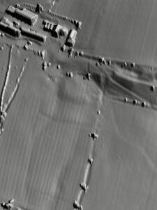
HVCP members decided to follow up the theory by looking at the area, initially using free online Lidar (Light Detection and Ranging) imagery. This revealed a flat platform of land in a field that looked like it could have been the site of a building. A site visit revealed that the platform lies between two springs. The field, that is now pasture, has evidence of rig and furrow dating from medieval cultivation. The rig and furrow extends up onto the platform indicating that if there was once a building it disappeared before enclosure removed the medieval field system, so before 1775 in the case of Kildale but it could have gone much earlier.
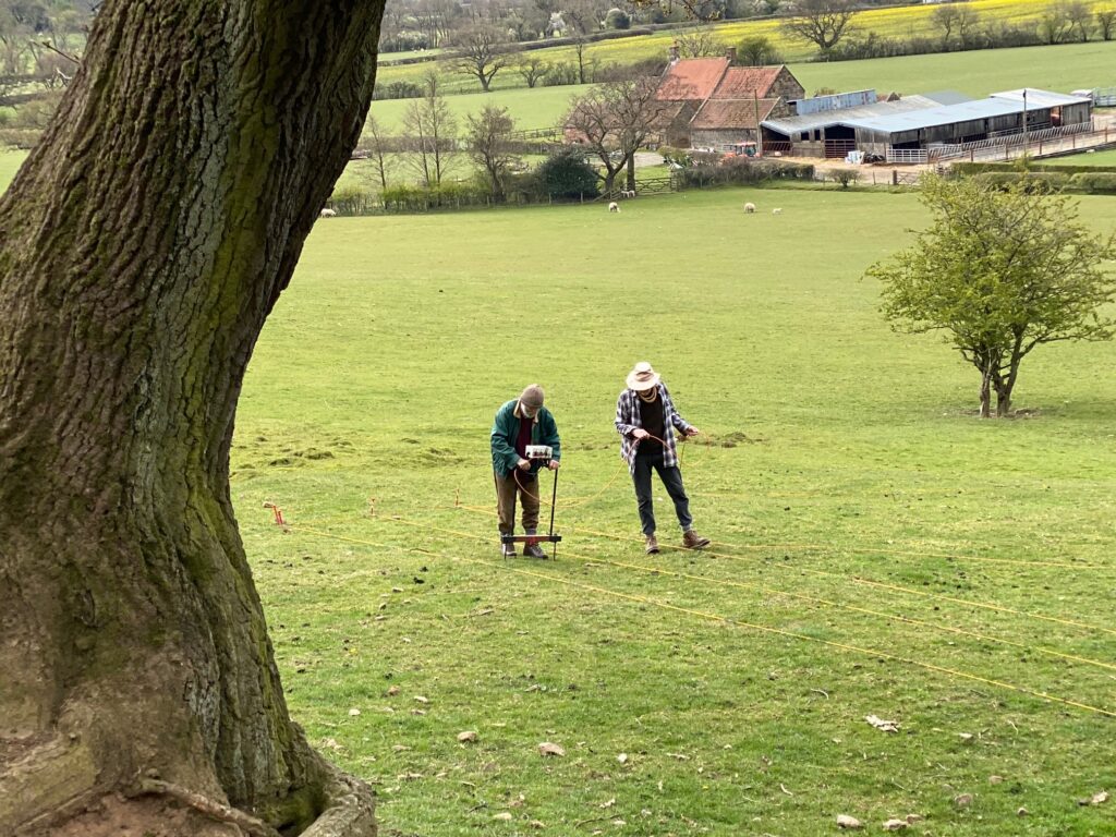
Geophysical survey
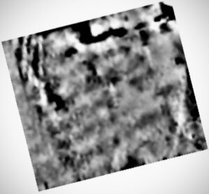
The field observations were consistent with a chapel that was in use before 1312 being on the platform, but more information was required. Group members carried out a geophysical survey on the platform using electrical resistance. An area of high resistance, appearing black on the plot of the results, right on the edge of the area selected for survey indicates stone beneath the ground surface forming the base of a substantial wall that could be from the lost chapel. The geophysical survey was followed by a topographic survey to accurately map the land forms on and around the platform.
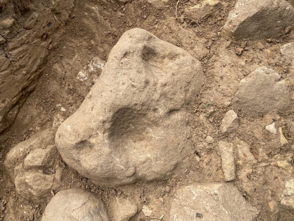
We were very pleased to have gained permission from the landowner and the farmer to excavate the wall line. Excavations began on Wednesday 19th May 2021, and continued throughout the summer.
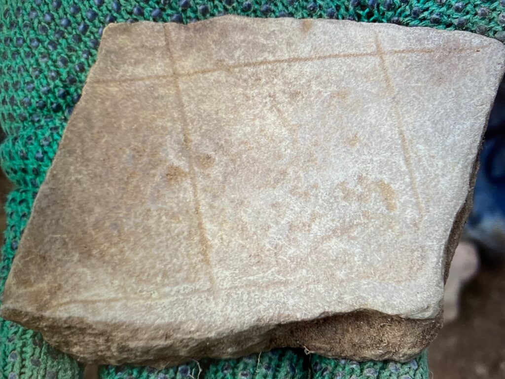
That first year of excavation confirmed the existence of a walls but whether we have the remains of a chapel or perhaps a farm building that used stone from the old chapel remains to be seen. Over 800 pieces of pottery were found, which is a great start.
At the end of the 2021 season a second geophysical survey was carried out. This original report has been amalgamated into the subsequent report below.
Trench #1 Plan
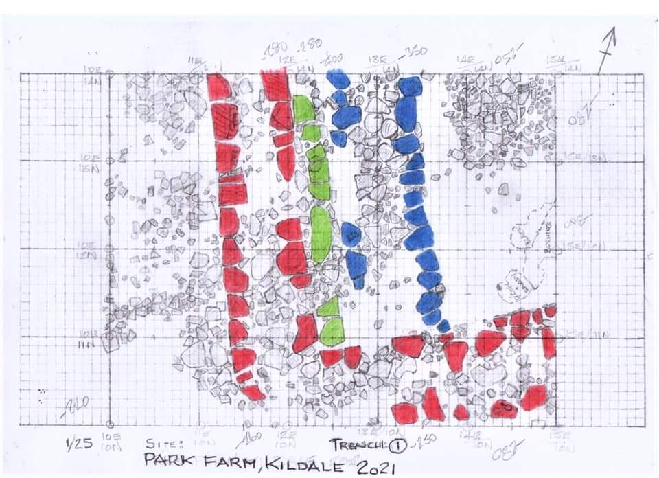
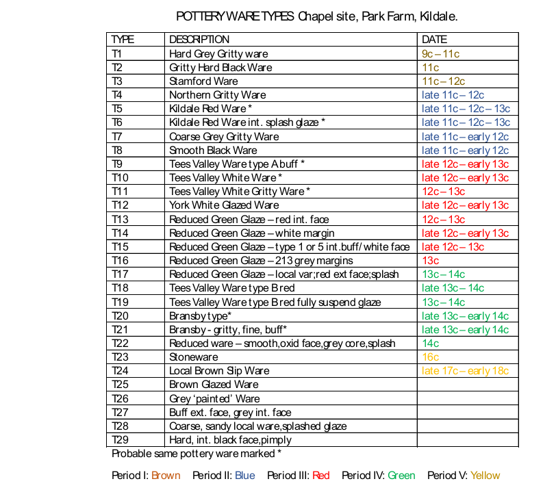
Pottery types found
The location of all the pottery sherds found was recorded on the day, with washing and cleaning carried out offsite. During the winter, three pottery workshops were held in which the sherds were grouped by type and attempts made to match and stick pieces together, with some success.
2nd geophysical survey
The 2021 season concluded with a supplementary geophysical survey principally on the lower platform. This proved fairly inclusive.
2022 Season Update Trench Plan
The plan is available here.
Footnotes
- 1
- 2Ridley, I.R. “The Changing Face of Kildale”. Stokesley & District Local History Study Group. 1985.