This paper by our Chairman Roger Inman has been submitted for publication in the 2024 Bulletin (No. 28) of the Teesside Archaeological Society. It summarises what we have done so far and gives his theories on what we have found.
MEDIEVAL CHAPEL IN KILDALE
Over the past three years members of the Hidden Valleys Community Project (HVCP) have been excavating a Medieval Chapel in Kildale which was dedicated to St.Hilda.
During 2020 and 2021 three members came across two references to the chapel. One was by Canon Atkinson(1) and the other was in Major Turton’s 1932 paper(2).
They also found a lease between Sir William de Percy and the Augustinian canons at Healaugh Park near Tadcaster.
The lease is dated to about 1250AD and grants the canons the use of the chantry chapel (implying that there was a chapel already there), much land and the use of the mill. In return they had to say masses for the souls of the de Percys who probably arrived in Kildale in about 1100AD.
The canons stayed in Kildale until about 1290/1305AD. By 1310AD the Brothers of the Cross or Crutched Friars were in possession of the chapel but in 1314AD they were told to leave Kildale and it is probable that by 1350AD the chapel had been demolished.
In 2021 after seeing a distinct platform on a Lidar image near the suspected position of the chapel by Major Turton, several members visited the platform which measured about 25m by 30m. Permission to investigate the site was granted by the owner and the tenant and on 2nd May a resistivity geophysical survey was undertaken by the members. On 9th May a topographical survey was carried out and trench one was de-turfed on the 19th May.
The resistivity survey produced a very clear response or thick black line on the northern edge of the platform (see plan 1 at the end) which turned out to be the southern wall of a large building. During 2021 and 2022 six trenches were excavated over this building.
In fact it was two buildings with a dividing wall between them (see plan 2). Building 1 was the domicile where the canons lived and building 2 was the chapel. The domicile measured 5.2m east-west by 3.5m internally with walls about 900mm wide. The chapel measured 8.5m east-west by 4.5m internally with 800mm wide walls.
Building 1 produced a large amount of pottery, much of it covered in soot and feature 65 in the chapel was very probably a sacrarium which was a soakaway device to dispose of sacred fluids and only found in churches and chapels.
During the excavations it became clear that there were at least five features that indicated major changes or alterations to the original structure.
The western wall of the domicile (feature 12) had been replaced with a substantial new wall (feature 8), with slab foundations, just outside the original wall which increased the domicile length to 6.5m.
The eastern wall of the domicile/western wall of the chapel had been demolished leaving a channel or gully – feature 61.
After the above wall had been demolished, the resulting gap between the north walls of the domicile and the chapel had been filled by random cobbling – feature 83.
The southern wall and the southern part of the east wall of the chapel had been rebuilt to a poorer standard of construction as seen in the outside face of the east wall. They also used a broken stone cross, similar to White Cross/Fat Bettys in Rosedale, as part of the foundations.
Feature 105 appears to be a new wall of a single line of stones inserted into the eastern end of the chapel and bedded into the east wall on three small stones.
Other features of interest include feature 98 which was a running spring. It appears that a
sump or pit had been dug into the solid clay beneath the spring possibly to make water collection easier.
Not only did the spring cause problems to those excavating the trench but also to those that built the domicile north wall. To counteract this problem the builders laid a lower level of very large stones under the main foundations.
Feature 42 was a large post-hole buried beneath a drain (feature 32) which was part of the western wall rebuild (8). This contained two substantial lumps of wood which turned out to be Oak heart wood with 16 growth rings.
Feature 54 was a large pit filled with grey clay (not cess), pottery and slivers of Oak. It may have been associated with the drain as another water sump.
It is likely that the chapel was built completely in stone. We found two stone window sill and a broken window arch in the demolition rubble south of the chapel, together with large squared and worked blocks of stone and very many stone roof tiles with peg or nail holes in them. These tiles were found in heaps, in gullies, in the drain and in much of the backfill. In places the eastern wall survived to four courses of stonework well above that needed for a timber structure.
It is probable that the domicile had stone foundations but an upper structure made of wood and daub panels (sill beam construction). Amongst the stones of the domicile western wall rebuild (8) were some worked stones with corner chamfers which is common in later period sill beam structures. Large lumps of white slag were found amongst the rubble north of the domicile north wall. This slag was found to be pure calcium carbonate, which when crushed to a powder and water added, became white lime wash which could have been used to paint the daub panels.
Unfortunately we cannot prove the above because we found only the very lowest level of the foundations. The domicile was built on rounded cobbles, possibly from the River Leven or field clearances, whereas the chapel was built on quarried squared stone. We found no evidence of solid flooring. The natural clay falls at 1in 9 (about 2m) east to west and feature 105 falls at 1 in 10. A considerable amount of stonework would have been needed to bring it up to a levelling off course and the floors filled up to match except against the inside of the east wall. It is probable that there was a step in the floor levels either side of the dividing wall of about 800mm. When the wall was removed it would have taken about 1.3m of fill against the western wall to level up the floor. Alternatively the original floors were kept and about 6 steps inserted where the dividing wall had been.
There is a gap in the southern chapel wall which was probably a doorway (feature 120), measuring about 750mm wide outside of which was a path of compacted small stones.
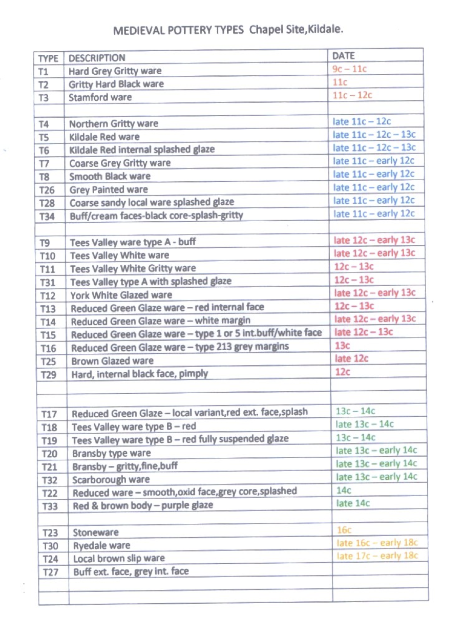
To those that are familiar with Medieval pottery it is well known that the pottery ware date spans are very broad but with expert advice 34 different wares and three occupation time zones have been identified. 1738 pieces of pottery have been recovered from the two buildings with the majority coming from the domicile and only a handful from the chapel.
Also recovered was a coin of Richard I, some glass beads and droplets, a great quantity of iron nails and some pieces of Iron Age/Romano-British pottery.
The time zones (see table 1 at the end) are: BLUE from when the de Percys arrived in Kildale ten years either side of 1100AD (we know a Viking called Orm held Kildale Manor at the time of the Domesday Book) to approximately 1150AD.
RED from 1150AD to about 1250AD.
GREEN from 1250AD to about 1350AD.
Green obviously coincides with the time when the Augustinian canons and the Crutched Friars leased the chapel and conversely the blue and red are pre-lease.
Unfortunately there was very little remaining stratigraphy over most of the buildings but where there was any depth of fill above the foundations it was found that the pottery time zones were mixed up and inverted. The greatest depth of fill was under the drain (32) and over feature 42 reaching over 1.2m deep. The excavators took great care to record the depths of each piece of pottery in the hope that some sort of time sequence could be obtained.
It was found that the time zones had been completely inverted – green at the bottom and blue at the top. From that it can be concluded that the demolition material had been mixed up and dumped across the site. Alternatively there may have been a midden nearby where rubbish had been thrown out with the earlier pottery at the bottom and the later pottery at the top. When this was thrown back into the drain and over the other parts of site the pottery sequence became inverted.
However there was no green time zone (canon & friar) pottery found in the fill under the walls and sacrarium. This must imply that the two buildings were constructed by the canons or friars.
Also the fill of the gully feature 61 (remains of the dividing wall) contained green zone pottery confirming that the wall was removed during the canon period.
It can be concluded that domicile and chapel were built by the canons after 1250AD.
Whether it was the canons or friars (probably the latter) who altered the buildings it is not possible to be sure. The rebuilding involved rebuilding the domicile west wall (8) and added an external drain (32), the removal of the dividing wall, moving the southern chapel wall south by about 900mm and adding the single stone width wall (feature 105).
The west wall would have been the highest wall on the site and probably a gable end with the ridges running east-west. It is possible that post-hole 42 was the remains of a derrick vertical post which would have been used to hoist up roof timbers during the rebuild.
Wall 105 was placed about one-third way across the width of the east end of the chapel and could well have been a sleeper wall (together with another wall further north) that supported a wooden floor maybe even a platform perhaps with the altar on it.
Features 57 and 58 may have been foundations for pillars which could have been part of a screen separating the friars or canons from the congregation. This would have created a building 16.3m long internally although it does have an appearance of work in progress.
However, large quantities of pre-canon (blue & red) pottery were found under the walls, under the sacrarium, and amongst the back filling of the site after demolition. No evidence was found for an earlier structure under or associated with the stone buildings. It has also been a puzzle to us why the stone buildings were built on the northern edge of the platform instead of the relatively level centre.
In 2023 it was decided to investigate the above two conundrums together with the intermittent black responses found by the resistivity survey over the remaining part of the site platform. It was also hoped that we could find the source of the Iron Age/Romano-British pottery.
Seven 4m and 5m square test trenches were opened-up but were soon amalgamated when we started to find substantial stone features (see preliminary plan 3).
The first feature (w128) was the eastern wall and parts of the southern and northern walls of a stone building measuring 3.5m north-south all badly damaged by later ploughing. If it was extended to the edge of the platform, it would have been about the same size as the domicile.
Attached to the south-eastern corner of this building was a line of large stones running north-south (feature w132).
About 400mm east of both features was feature 154. This was a 1.10m wide band of compacted stones or cobbles which cornered and headed east for 4.5m. The northern end of the north-south leg was very ragged as though it had been deliberately broken up.
Cutting through the northern end of the cobbles and under wall w128 was a gully (feature g170). At its western end it was 700mm wide but where it cut the cobbles it was only 250mm wide. This end terminated in the area to the east of the cobbles as if to drain it.
Wall feature w180 was possibly the remains of a building south of the southern leg of the cobbles.
Four other gullies were found cut into the natural clay similar to feature g138. The latter had four smaller lower gullies underneath it which contained blue and red time zone (pre-canon) pottery. The other gullies await excavation.
About half of the cobbled band was removed to obtain dating evidence from underneath it.
The fill under the cobbles contained green (canon) pottery (23%) but the greatest quantity of pottery was pre-canon (blue & red) (77%). That implies that the cobbles were laid after 1250AD. The space enclosed by the cobbles was also subjected to pottery distribution graphs. Of the 128 pieces at the same level as the top of the cobbles or below 13% were green (canon) and 87% pre-canon. The fact that canon pottery was found in that space must also mean that it was in use during the canon’s occupancy.
Gully g170 was filled with large slat (thin & flat) stones some of which were roof tiles and some of these were found at a steep angle where they had fallen in against the inside of the open gully.
There is an earlier gully underneath but that has yet to be investigated.
The feature time sequence must start with the cobbles, or possibly a cloister walk, and the lower gully. The former seems to line up with the outside of the first western wall of the domicile and with the later pottery under it may well be contemporary.
When the western wall was extended the cobbles or cloister was no longer needed so the northern end of it was dug up.
It is possible that the area enclosed by the cobbles was a garden or vegetable plot which may have continued in used after the demise of the cobbles hence the need for a later gully or drain. The pottery time zones from the garden area were very mixed up which could have been the result of turning the soil before planting.
There is a chance that the later gully (g170) not only discharged as a re-cut at its western end heading for the platform edge but also connected to the drain (32) outside the later western domicile wall. This has yet to be explored.
When the domicile and chapel were being demolished the gully was filled with unwanted roofing tiles and backfilled.
The last feature was w128 built over the infilled gully and even used one of the tiles as part of its construction. Wall feature w132 was probably contemporary with the building w128.
Although the amount of Iron Age/Romano-British pottery has increased dramatically we have yet to find any features linked to that period.
Also to be resolved is the reason for all the pre-canon (blue & red) pottery found in large quantities under and over the stone buildings, under and over the cobbles and in the garden area.
During 2024 we hope to investigate the earlier gully under g170, find the extent of the cobbles or cloister, find the extent of wall feature 180 and explore the remaining black geophysical responses.
The six trenches over the stone buildings 1 & 2 were back filled in 2022 and 2023.
We would like to thank Andrew Sutcliffe the owner of the Kildale Estate and the tenants David and Carol Cook for their support and friendship.
We would like to thank Anne Jenner of York Archaeology for her help analysing the pottery.
Thanks to Charlotte O’Brien of Durham Archaeological Services with her help identifying the wood samples.
Thanks to Miles Johnson and the North York Moors National Park for their financial support.
References:
- 1. Canon Atkinson Cleveland Ancient and Modern p.309
- 2. Major R.B.Turton A Few Cleveland Place Names in Cleveland Naturalists’ Field Club Proceedings 1932 p.42
Hidden Valleys Community Project January 2024.
PLAN 1.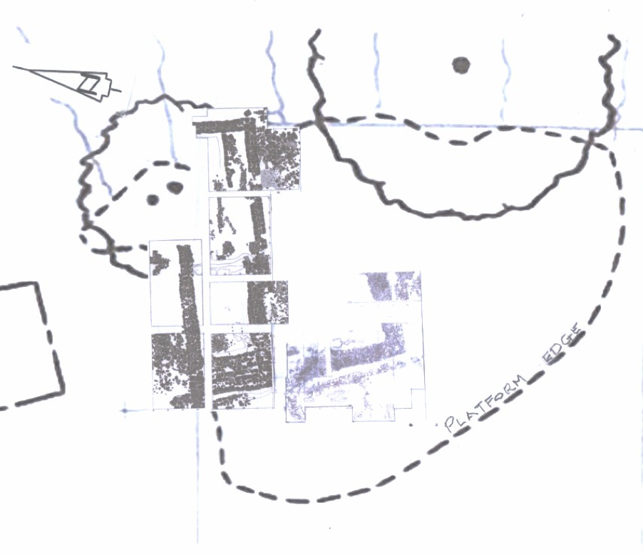
PLAN 2.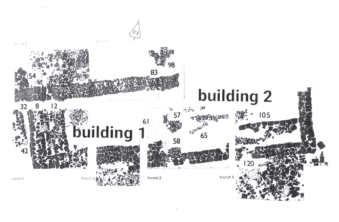
PLAN 3.
PHOTOGRAPH 1.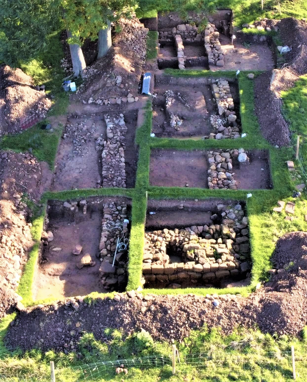
Drone photograph courtesy of Martin and Rosie Norman.
East is at the top of the photograph.
TABLE 1.