Our excavations at Park Farm have been much more productive than anticipated.
Over the last two years we found substantial walling – very tactile and very obvious.
However, this year it was suspected that we would find only ditches, gullies, and postholes.
Instead we found three sides of a stone building with an attached stone wall, two sides of a cobbled area, evidence of two other walls and at least five gullies.
Obviously there is much post-excavation work to be done, least of all the analysis of the 865 pieces of pottery some of which were clearly Iron Age/Romano-British.
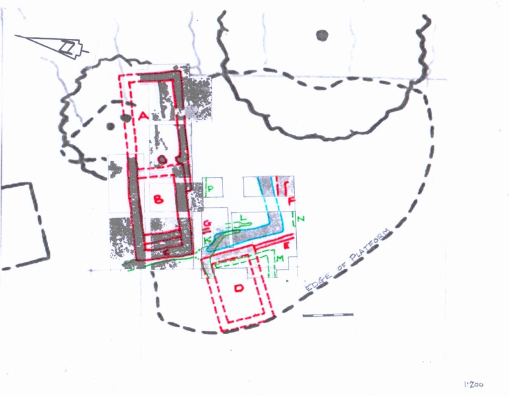
The attached plan is a composite of the ’21 and ’22 excavations and this year’s excavations on top of the topographical survey showing the extent of the platform.
All the stone walling is coloured red.
Building A is the chapel. Building B is the domicile with the western extension C.
From this year’s excavations we know the width of Building D but when extended to the edge of the platform it becomes almost identical in size to the domicile or chapel. Perhaps this is the earlier chapel hinted at in the lease to the Canons in 1250AD.
Wall E is a single line of large stones attached to the corner of building D and was probably a paddock wall. Both the last two features have been badly damaged by ploughing.
Wall F could be the remains of two sides of another building which will have to investigated next year.
Wall G is a short single stone wall over some earlier gullies and is of unknown use.
The cobbled area, coloured blue, consists of compacted stones and measures about 1.2m wide. It seems to respect and is on the same alignment as building D but the ragged northern end of the western side suggests that part of it was ripped up when the domicile was built. Next year it is hoped that we will find the eastern side. Two sections of the western side of the cobbles were removed to down natural in order to obtain pottery dating evidence.
It is possible that the cobbled area may form two sides of a quadrangle or cloister with paving laid over the top of the cobbles. The area enclosed by the cobbles may have been a kitchen garden which is common on some monastic sites. The pottery from the garden area appears to be mixed up chronologically which is to be expected if the garden had been worked with a spade.
The gullies are coloured green.
Gully K appears to have two phases. The last phase was backfilled using some roof tiles and may connect to the drain west of the west wall of the domicile. Gully L may be part of the earlier phase. Gully M was seen in the upper fill levels but was represented in the natural clay as shallow gullies containing Medieval pottery. Gullies N and P have yet to be fully explored.
It is assumed that gullies K and L were drains associated with the garden area.
The dating for all these features has yet to be established but it is certain that they are all Medieval and may date to the pre-Canon era (pre-1250AD).
We have still to find features associated with the Iron Age/Romano-British period.
Roger Inman Oct. 2023.